

Welcome to the Hydrologic Engineering Center’s (CEIWR-HEC) River Analysis System (HEC-RAS) website. This software allows the user to perform one-dimensional steady flow, one and two-dimensional unsteady flow calculations, sediment transport/mobile bed computations, and water temperature/water quality modeling.
HEC-RAS is designed to perform one and two-dimensional hydraulic calculations for a full network of natural and constructed channels. The following is a description of the major capabilities of HEC-RAS.
User Interface
The user interacts with HEC-RAS through a graphical user interface (GUI). The main focus in the design of the interface was to make it easy to use the software, while still maintaining a high level of efficiency for the user. The interface provides for the following functions:
Hydraulic Analysis Components
The HEC-RAS system contains several river analysis components for: (1) steady flow water surface profile computations; (2) one- and two-dimensional unsteady flow simulation; (3) movable boundary sediment transport computations; and (4) water quality analysis. A key element is, that all four components use a common geometric data representation and common geometric and hydraulic computation routines. In addition to these river analysis components, the system contains several hydraulic design features that can be invoked once the basic water surface profiles are computed.
Steady Flow Water Surface Profiles
 This component of the modeling system is intended for calculating water surface profiles for steady gradually varied flow. The system can handle a full network of channels, a dendritic system, or a single river reach. The steady flow component is capable of modeling subcritical, supercritical, and mixed flow regimes water surface profiles.
The basic computational procedure is based on the solution of the one-dimensional energy equation. Energy losses are evaluated by friction (Manning’s equation) and contraction/expansion (coefficient multiplied by the change in velocity head). The momentum equation may be used in situations where the water surface profile is rapidly varied. These situations include mixed flow regime calculations (i.e., hydraulic jumps), hydraulics of bridges, and evaluating profiles at river confluences (stream junctions)
One- and Two-Dimensional Unsteady Flow Simulation
 This component of the HEC-RAS modeling system is capable of simulating one-dimensional; two-dimensional; and combined one/two-dimensional unsteady flow through a full network of open channels, floodplains, and alluvial fans. The unsteady flow component can be used to performed subcritical, supercritical, and mixed flow regime (subcritical, supercritical, hydraulic jumps, and draw downs) calculations in the unsteady flow computations module.
Special features of the unsteady flow component include: extensive hydraulic structure capabilities Dam break analysis; levee breaching and overtopping; Pumping stations; navigation dam operations; pressurized pipe systems; automated calibration features; User defined rules; and combined one and two-dimensional unsteady flow modeling.
Steady Transport/Movable Boundary Computations
This component of the modeling system is intended for the simulation of one-dimensional sediment transport/movable boundary calculations resulting from scour and deposition over moderate time periods (typically years, although applications to single flood events are possible).
The sediment transport potential is computed by grain size fraction, thereby allowing the simulation of hydraulic sorting and armoring. Major features include the ability to model a full network of streams, channel dredging, various levee and encroachment alternatives, and the use of several different equations for the computation of sediment transport.
The model is designed to simulate long-term trends of scour and deposition in a stream channel that might result from modifying the frequency and duration of the water discharge and stage, or modifying the channel geometry. This system can be used to evaluate deposition in reservoirs, design channel contractions required to maintain navigation depths, predict the influence of dredging on the rate of deposition, estimate maximum possible scour during large flood events, and evaluate sedimentation in fixed channels.
Water Quality Analysis
This component of the modeling system is intended to allow the user to perform riverine water quality analyses. An advection-dispersion module is included with this version of HEC–RAS, adding the capability to model water temperature. This new module uses the QUICKEST-ULTIMATE explicit numerical scheme to solve the one-dimensional advection-dispersion equation using a control volume approach with a fully implemented heat energy budget. Transport and Fate of a limited set of water quality constituents is now also available in HEC-RAS. The currently available water quality constituents are: Dissolved Nitrogen (NO3-N, NO2-N, NH4-N, and Org-N); Dissolved Phosphorus (PO4-P and Org-P); Algae; Dissolved Oxygen (DO); and Carbonaceous Biological Oxygen Demand (CBOD).
Data Storage and Management
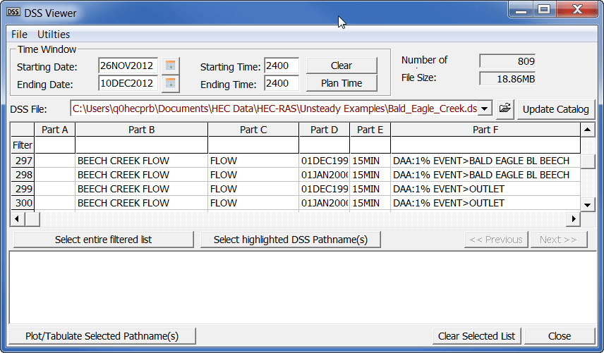 Data storage is accomplished through the use of “flat” files (ASCII and binary), the HEC-DSS (Data Storage System), and HDF5 (Hierarchical Data Format, Version 5). User input data are stored in flat files under separate categories of project, plan, geometry, steady flow, unsteady flow, quasi-steady flow, sediment data, and water quality information. Output data is predominantly stored in separate binary files (HEC and HDF5). Data can be transferred between HEC-RAS and other programs by utilizing the HEC-DSS. Data management is accomplished through the user interface. The modeler is requested to enter a single filename for the project being developed. Once the project filename is entered, all other files are automatically created and named by the interface as needed. The interface provides for renaming, moving, and deletion of files on a project-by-project basis.
Graphics and Reporting
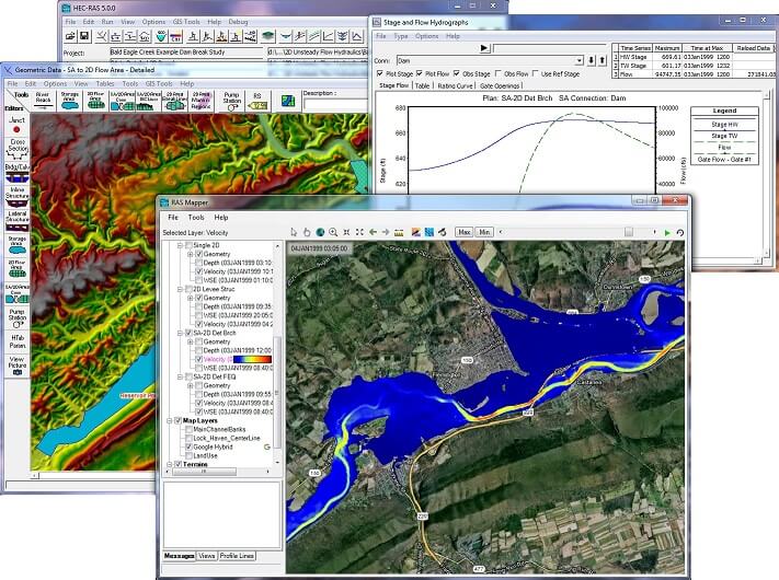
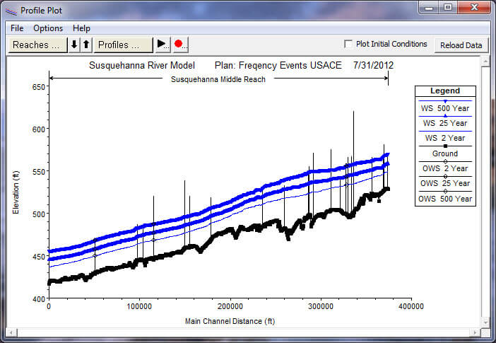
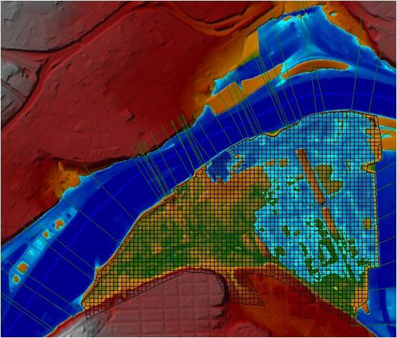
Graphics include X-Y plots of the river system schematic, cross-sections, profiles, rating curves, hydrographs, and inundation mapping. A three-dimensional plot of multiple cross-sections is also provided. Inundation mapping is accomplished in the HEC-RAS Mapper portion of the software. Inundation maps can also be animated, and contain multiple background layers (terrain, aerial photography, etc…). Tabular output is available. Users can select from pre-defined tables or develop their own customized tables. All graphical and tabular output can be displayed on the screen, sent directly to a printer (or plotter), or passed through the Windows Clipboard to other software, such as a word-processor or spreadsheet.
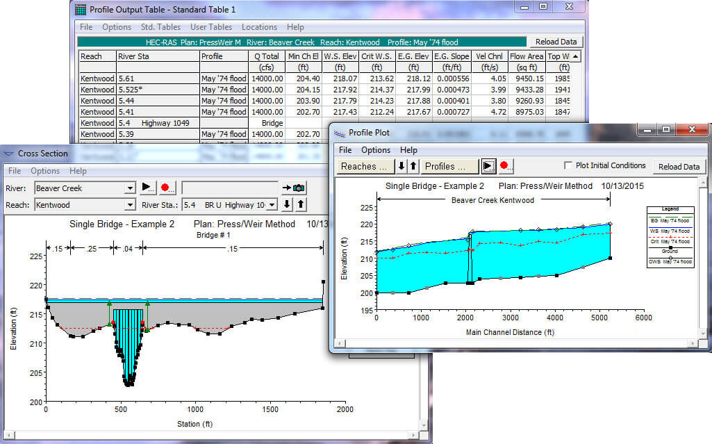
Reporting facilities allow for printed output of input data as well as output data. Reports can be customized as to the amount and type of information desired.
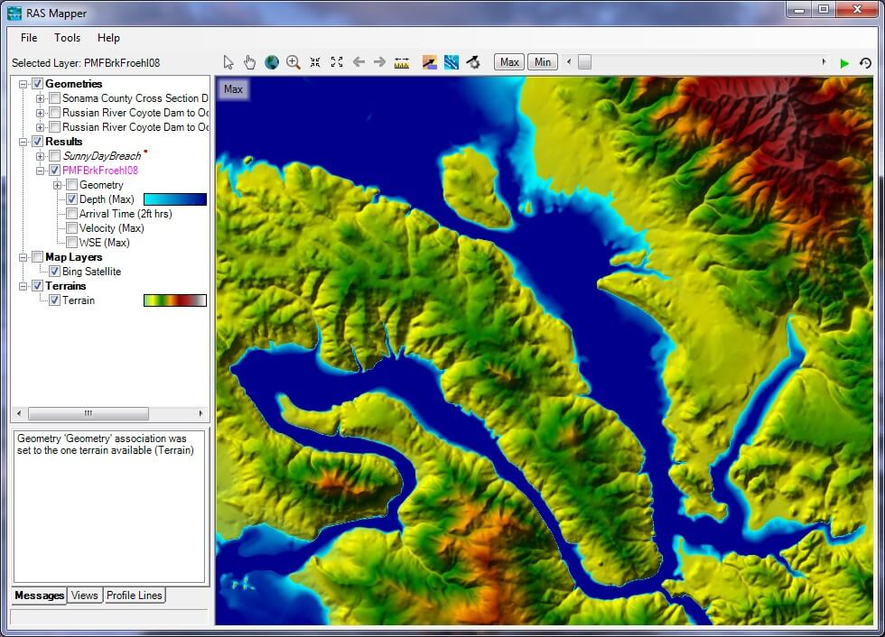
RAS Mapper
HEC-RAS has the capability to perform inundation mapping of water surface profile results directly from HEC-RAS. Using the HEC-RAS geometry and computed water surface profiles, inundation depth and floodplain boundary datasets are created through the RAS Mapper. Additional geospatial data can be generated for analysis of velocity, shear stress, stream power, ice thickness, and floodway encroachment data. In order to use the RAS Mapper for analysis, you must have a terrain model in the binary raster floating-point format (.flt). The resultant depth grid is stored in the .flt format while the boundary dataset is store in ESRI’s Shapefile format for use with geospatial software.


Reviews
There are no reviews yet.